null
DJI P4 Multispectral Agriculture Drone (CP.AG.00000206.01)

DJI P4 Multispectral Agriculture Drone

×

Sorry this item is currently out of stock

×
Brand:
Price:
$6,499.00
SKU:
CP.AG.00000206.01a
Availability:
Usually Ships Within 1 Business Day
Shipping:
Calculated at checkout
Description
Specifications
Product Videos
Specifications
Reviews
Related Products
Also Viewed
By Category
  • Product Description

    DJI P4 Multispectral Agriculture Drone

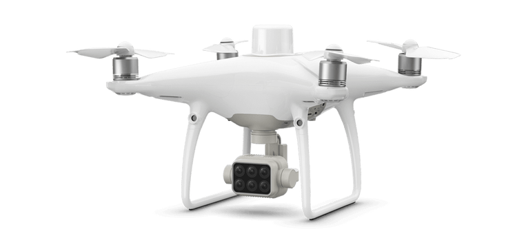
    The P4 Multispectral is a fully integrated multispectral imaging drone designed for precision agriculture and environmental management. Combining data from six separate sensors to measure the health of crops, from individual plants to entire fields, as well as weeds, insects and a variety of soil conditions, the P4 Multispectral sets a new standard for easy-to-use agricultural drone applications.

    djimulti.png

    Farm to Figures

    Gain Immediate Insights into Plant Health

    The P4 Multispectral consolidates the process of capturing data that gives insight into crop health and vegetation management. DJI has created this platform with the same powerful performance standards that DJI is known for, including 27 minutes max flight time and up to 7 km1 transmission range with the OcuSync system.

     djimulti2.png

    See Beneath the Surface

    Agriculture imagery collection is now simpler and more efficient than ever before with a built-in stabilized imaging system that collects comprehensive data sets right out of the box. Access information collected by 1 RGB camera and a multispectral camera array with 5 cameras covering Blue, Green, Red, Red Edge, and Near Infrared bands – all at 2 MP with global shutter, on a 3-axis stabilized gimbal.

    djimultis3.png

    djimultis4.png

    Meaningful Data at Your Disposal

    View Both RGB and NDVI Feeds

    Simply having aerial imagery is not enough for ag professionals who want to know more. Switch between a preliminary Normalized Difference Vegetation Index (NDVI) analysis and the live RGB feed to immediately visualize where attention is needed, so targeted treatment decisions can be made quickly.

    djimultis5.png

    Centimeter-level Precision

    Get real-time, accurate positioning data on images captured by all six cameras with DJI’s TimeSync system, providing centimeter-level accurate measurements. The TimeSync system continually aligns the flight controller, RGB and NB cameras, and RTK module, fixing the positioning data to the center of the CMOS and ensuring each photo uses the most accurate metadata. All cameras go through a rigorous calibration process where radial and tangential lens distortions are measured. The distortion parameters gathered are saved into each image’s metadata, letting post-processing software adjust uniquely for every user.


    djimultis6.png

    D-RTK 2 Mobile Station and NTRIP Compatibility

    Enhance the accuracy of RTK positioning without internet connection by connecting the P4 Multispectral to the D-RTK 2 High Precision GNSS Mobile Station and NTRIP (Network Transport of RTCM via Internet Protocol)2, or store the satellite observation data to be used for Post Processed Kinematics (PPK).

    djimultis7.png

    The Beginning of Intelligent Agriculture Missions

     djimultis8-1.png djimultis8-3.png
     djimultis8-2.png  djimultis84-2.png

     Applications

    djimultis9.png


    Precision agriculture | Environmental monitoring and inspection
    Throughout all growing seasons, multispectral imagery can be helpful to ag professionals by providing information invisible to the human eye across the electromagnetic spectrum. Having access to this data and the subsequently obtained Vegetation Index data such as NDRE and NDVI, farmers can make timely, informed decisions on crop treatment, lowering costs, saving resources, and maximizing yields.
    Routine inspections and maintenance involving plants can be made smarter and more efficient when using the P4 Multispectral – leverage its actionable multispectral insights to monitor forest health, measure biomass, map shorelines, or manage riparian vegetation while protecting habitats or ecosystems, and much more.


    p4multis.png

    Plant Intelligence for Targeted Action.

    Receive with purchase a complimentary license to the following:

    1 year DJI GS Pro (Team-Professional) - 1 year DJI Terra Basic - 1 year Enterprise Shield Basic 

    • Whats in the Box
    • 1x DJI Phantom 4 Multispectral Drone
    • 1x Remote Controller
    • 4x Propeller (pair)
    • 2x Phantom 4 Intelligent Flight Battery
    • 1x AC Power Adapter
    • 1x AC Power Cable
    • 1x Intelligent Flgiht Battery Charging Hub
    • 1x Gimbal Lock
    • 1x MicroSD card
    • 1x Micro USB Cable
    • 1x Year DJI Enterprise Shield Basic
    SPECS
    Aircraft
    • Takeoff Weight

    • 1487 g
    • Diagonal Distance (Propellers Excluded)

    • 350 mm
    • Max Service Ceiling Above Sea Level

    • 19685 ft (6000 m)
    • Max Ascent Speed

    • 6 m/s (automatic flight); 5 m/s (manual control)
    • Max Descent Speed

    • 3 m/s
    • Max Speed

    • 31 mph (50 kph) (P-mode); 36 mph (58 kph) (A-mode)
    • Max Flight Time

    • Approx. 27 minutes
    • Operating Temperature

    • 0° to 40° C (32° to 104° F)
    • Operating Frequency

    • 2.4000 GHz to 2.4835 GHz (Europe, Japan, Korea)
      5.725 GHz to 5.850 GHz (Other countries/regions)[1]
    • Transmission Power (EIRP)

    • 2.4 GHz: < 20 dBm (CE / MIC / KCC)
      5.8 GHz: < 26 dBm (FCC / SRRC / NCC)
    • Hover Accuracy Range

    • RTK enabled and functioning properly:
      Vertical: ± 0.1 m; Horizontal: ± 0.1 m
      RTK disabled:
      Vertical: ± 0.1 m (with vision positioning); ± 0.5 m (with GNSS positioning)
      Horizontal: ± 0.3 m (with vision positioning); ± 1.5 m (with GNSS positioning)
    • Image Position Compensation

    • The relative positions of the centers of the six cameras’ CMOS and the phase center of the onboard D-RTK antenna have been calibrated and are recorded in the EXIF data of each image.

    GNSS

    • Single-Frequency High-Sensitivity GNSS

    • GPS + BeiDou + Galileo[2] (Asia); GPS + GLONASS + Galileo[2] (other regions)
    • Multi-Frequency Multi-System High-Precision RTK GNSS

    • Frequency Used
      GPS: L1/L2; GLONASS: L1/L2; BeiDou: B1/B2; Galileo[2]: E1/E5
      First-Fixed Time: < 50 s
      Positioning Accuracy: Vertical 1.5 cm + 1 ppm (RMS); Horizontal 1 cm + 1 ppm (RMS).
      1 ppm indicates error with a 1 mm increase over 1 km of movement.
      Velocity Accuracy: 0.03 m/s

    Mapping Functions

    • Ground Sample Distance (GSD)

    • (H/18.9) cm/pixel, H indicates the aircraft altitude relative to the area mapped (unit: m)
    • Rate of Data Collection

    • Max operating area of approx. 0.47 km2 for a single flight at an altitude of 180 m, i.e., GSD is approx. 9.52 cm/pixel

    Gimbal

    • Controllable Range

    • Tilt: -90° to +30°

    Vision System

    • Velocity Range

    • ≤ 31 mph (50 kph) at 6.6 ft (2 m) above ground with adequate lighting
    • Altitude Range

    • 0 - 33 ft (0 - 10 m)
    • Operating Range

    • 0 - 33 ft (0 - 10 m)
    • Obstacle Sensory Range

    • 2 - 98 ft (0.7 - 30 m)
    • Operating Environment

    • Surfaces with clear patterns and adequate lighting (> 15 lux)

    Camera

    • Sensors

    • Six 1/2.9” CMOS, including one RGB sensor for visible light imaging and five monochrome sensors for multispectral imaging.
      Each Sensor: Effective pixels 2.08 MP (2.12 MP in total)
    • Filters

    • Blue (B): 450 nm ± 16 nm; Green (G): 560 nm ± 16 nm; Red (R): 650 nm ± 16 nm; Red edge (RE): 730 nm ± 16 nm; Near-infrared (NIR): 840 nm ± 26 nm
    • Lenses

    • FOV (Field of View): 62.7°
      Focal Length: 5.74 mm (35 mm format equivalent: 40 mm), autofocus set at ∞
      Aperture: f/2.2
    • RGB Sensor ISO Range

    • 200 - 800
    • Monochrome Sensor Gain

    • 1 - 8x
    • Electronic Global Shutter

    • 1/100 - 1/20000 s (visible light imaging); 1/100 - 1/10000 s (multispectral imaging)
    • Max Image Size

    • 1600×1300 (4:3.25)
    • Photo Format

    • JPEG (visible light imaging) + TIFF (multispectral imaging)
    • Supported File Systems

    • FAT32 (£ 32 GB); exFAT (> 32 GB)
    • Supported SD Cards

    • microSD with a minimum write speed of 15 MB/s. Max Capacity: 128 GB. Class 10 or UHS-1 rating required
    • Operating Temperature

    • 0° to 40° C (32° to 104° F)

    Remote Controller

    • Operating Frequency

    • 2.4000 GHz to 2.4835 GHz (Europe, Japan, Korea)
      5.725 GHz to 5.850 GHz (Other countries/regions)[1]
    • Transmission Power (EIRP)

    • 2.4 GHz: < 20 dBm (CE / MIC / KCC)
      5.8 GHz: < 26 dBm (FCC / SRRC / NCC)
    • Max Transmission Distance

    • FCC / NCC: 4.3 mi (7 km)
      CE / MIC / KCC / SRRC: 3.1 mi (5 km)(Unobstructed, free of interference)
    • Built-in Battery

    • 6000 mAh LiPo 2S
    • Operating Current / Voltage

    • 1.2 A @ 7.4 V
    • Mobile Device Holder

    • Tablets and smartphones
    • Operating Temperature

    • 0° to 40° C (32° to 104° F)

    Intelligent Flight Battery (PH4-5870mAh-15.2V)

    • Capacity

    • 5870 mAh
    • Voltage

    • 15.2 V
    • Battery Type

    • LiPo 4S
    • Energy

    • 89.2 Wh
    • Net Weight

    • 468 g
    • Operating Temperature

    • -10° to 40° C (14° to 104° F)
    • Charging Temperature

    • 5° to 40° C (41° to 104° F)
    • Max Charging Power

    • 160 W

    Intelligent Flight Battery Charging Hub (PHANTOM 4 CHARGING HUB)

    • Voltage

    • 17.5 V
    • Operating Temperature

    • 5° to 40° C (41° to 104° F)

    AC Power Adapter (PH4C160)

    • Voltage

    • 17.4 V
    • Rated Power

    • 160 W

    NOTE

    •  

    • [1] To comply with local laws and regulations, this frequency is not available in some countries or regions.
      [2] Support for Galileo is coming soon.
  • Product Reviews

    ×

    This product hasn't received any reviews yet. Be the first to review this product!

    Write A Review

  • Product Videos

    • P4 Multispectral - Multispectral Imaging Drone Solution
      As the world population continues to grow, we need innovative ...

    P4 Multispectral - Multispectral Imaging Drone Solution

    As the world population continues to grow, we need innovative ways to feed more people sustainably. Meet the new tool that makes your workflow efficient - the DJI P4 Multispectral. Resources: P4 Multispectral - Everything about Your New Smart Agriculture Tool - https://bit.ly/3kmM0Q0 Multispectral Drones Streamline Assessments of Assieu Rapeseed Crops - https://bit.ly/3ydlayX Can Drones Help Your Farm - https://bit.ly/3B59jo9 Multispectral Imaging Drones for Agriculture - https://bit.ly/3sFcQqm Learn More: Subscribe: https://www.youtube.com/channel/UC9gL... Like us on Facebook: https://www.facebook.com/DJIEnterpris... Follow us on Twitter: http://www.twitter.com/DJIEnterprise Follow us on LinkedIn: https://www.linkedin.com/company/dji/ Website: https://www.dji.com/p4-multispectral
  • Find Similar Products by Category

×
×